![Item #3387 [WORLD MAP]. A New Chart of the World on Mercator's Projection with The Tracks & Discoveries of the Latest Circumnavigators &c. Samuel Dunn.](https://michaellaird.cdn.bibliopolis.com/pictures/3387.jpg?width=768&height=1000&fit=bounds&auto=webp&v=1620845709)
![[WORLD MAP]. A New Chart of the World on Mercator's Projection with The Tracks & Discoveries of the Latest Circumnavigators &c.](https://michaellaird.cdn.bibliopolis.com/pictures/3387_2.jpg?auto=webp&v=1620845709)
![[WORLD MAP]. A New Chart of the World on Mercator's Projection with The Tracks & Discoveries of the Latest Circumnavigators &c.](https://michaellaird.cdn.bibliopolis.com/pictures/3387_3.jpg?auto=webp&v=1620845709)
![[WORLD MAP]. A New Chart of the World on Mercator's Projection with The Tracks & Discoveries of the Latest Circumnavigators &c.](https://michaellaird.cdn.bibliopolis.com/pictures/3387_4.jpg?auto=webp&v=1620845709)
![[WORLD MAP]. A New Chart of the World on Mercator's Projection with The Tracks & Discoveries of the Latest Circumnavigators &c.](https://michaellaird.cdn.bibliopolis.com/pictures/3387_5.jpg?auto=webp&v=1620845709)
![[WORLD MAP]. A New Chart of the World on Mercator's Projection with The Tracks & Discoveries of the Latest Circumnavigators &c.](https://michaellaird.cdn.bibliopolis.com/pictures/3387_6.jpg?auto=webp&v=1620845709)
![[WORLD MAP]. A New Chart of the World on Mercator's Projection with The Tracks & Discoveries of the Latest Circumnavigators &c.](https://michaellaird.cdn.bibliopolis.com/pictures/3387_7.jpg?auto=webp&v=1620845709)
![[WORLD MAP]. A New Chart of the World on Mercator's Projection with The Tracks & Discoveries of the Latest Circumnavigators &c.](https://michaellaird.cdn.bibliopolis.com/pictures/3387_8.jpg?auto=webp&v=1620845709)
![[WORLD MAP]. A New Chart of the World on Mercator's Projection with The Tracks & Discoveries of the Latest Circumnavigators &c.](https://michaellaird.cdn.bibliopolis.com/pictures/3387_9.jpg?auto=webp&v=1620845709)
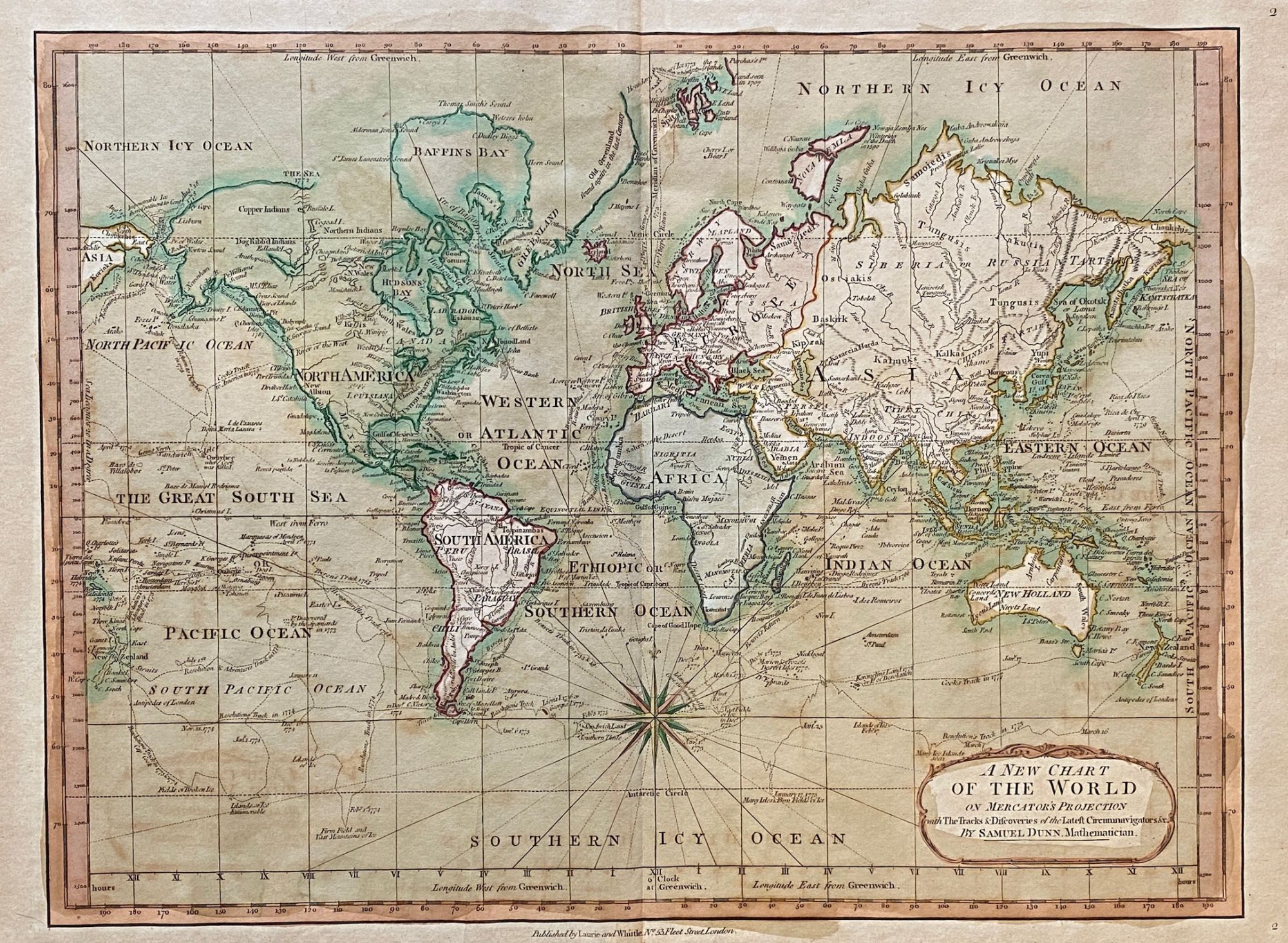
[WORLD MAP]. A New Chart of the World on Mercator's Projection with The Tracks & Discoveries of the Latest Circumnavigators &c.
London: Laurie and Whittle. No. 53, Fleet Street, 1789 (or 1794?). Original copper-engraved map with contemporary hand-colored outline and rather hastily-applied wash which in some instances extends into the outer margins. Professionally matted (visible size: 420 x 320 mm; 16.5" x 12.5"), very handsome 20th-century wood frame. Original engraving, NOT a reproduction! Very good. Item #3387
Fine 18th-century map of the world, showing the exploration routes and circumnavigations of Bouvet (1733 and 1739), Bougainville (1768), Byron (1765) and Cook (1773-1779), with other explorers' landfalls shown in the Pacific and Southern Oceans. Australia is shown as New Holland; New Zealand appears twice (sic!); and there is no indication of Antarctica. The map shows late eighteenth-century coastal cities and some geography of North America, South America, Europe, Asia, Africa, and Oceania.
Extracted from Samuel Dunn's "A New atlas of the mundane system; or, of geography and cosmography: describing the heavens and the earth, the distances, motions and magnitudes of the celestial bodies" (3rd or 4th ed.), London, Laurie & Whittle (1786-1789 or 1796).
Phillips, Geographical Atlases in the Library of Congress, no. 659, map 2 (3rd ed.) or no. 684, map. 2 (4th ed.).
Price: $650.00