![Item #3444 [HUGE MAP OF OREGON 1845]. Map of the Oregon Territory by the U.S. Ex. Ex. Charles Wilkes, Esqr. Commander 1841. [Inset map at left]: Columbia River Reduced from Survey Made by the U.S. Ex. Ex. 1841. [Below neat line at right]: J.H. Young & Sherman & Smith, N.Y. Charles Wilkes.](https://michaellaird.cdn.bibliopolis.com/pictures/3444.jpg?width=768&height=1000&fit=bounds&auto=webp&v=1616874895)
![[HUGE MAP OF OREGON 1845]. Map of the Oregon Territory by the U.S. Ex. Ex. Charles Wilkes, Esqr. Commander 1841. [Inset map at left]: Columbia River Reduced from Survey Made by the U.S. Ex. Ex. 1841. [Below neat line at right]: J.H. Young & Sherman & Smith, N.Y.](https://michaellaird.cdn.bibliopolis.com/pictures/3444_2.jpg?auto=webp&v=1616874895)
![[HUGE MAP OF OREGON 1845]. Map of the Oregon Territory by the U.S. Ex. Ex. Charles Wilkes, Esqr. Commander 1841. [Inset map at left]: Columbia River Reduced from Survey Made by the U.S. Ex. Ex. 1841. [Below neat line at right]: J.H. Young & Sherman & Smith, N.Y.](https://michaellaird.cdn.bibliopolis.com/pictures/3444_3.jpg?auto=webp&v=1616874895)
![[HUGE MAP OF OREGON 1845]. Map of the Oregon Territory by the U.S. Ex. Ex. Charles Wilkes, Esqr. Commander 1841. [Inset map at left]: Columbia River Reduced from Survey Made by the U.S. Ex. Ex. 1841. [Below neat line at right]: J.H. Young & Sherman & Smith, N.Y.](https://michaellaird.cdn.bibliopolis.com/pictures/3444_4.jpg?auto=webp&v=1616874895)
![[HUGE MAP OF OREGON 1845]. Map of the Oregon Territory by the U.S. Ex. Ex. Charles Wilkes, Esqr. Commander 1841. [Inset map at left]: Columbia River Reduced from Survey Made by the U.S. Ex. Ex. 1841. [Below neat line at right]: J.H. Young & Sherman & Smith, N.Y.](https://michaellaird.cdn.bibliopolis.com/pictures/3444_5.jpg?auto=webp&v=1616874895)
![[HUGE MAP OF OREGON 1845]. Map of the Oregon Territory by the U.S. Ex. Ex. Charles Wilkes, Esqr. Commander 1841. [Inset map at left]: Columbia River Reduced from Survey Made by the U.S. Ex. Ex. 1841. [Below neat line at right]: J.H. Young & Sherman & Smith, N.Y.](https://michaellaird.cdn.bibliopolis.com/pictures/3444_6.jpg?auto=webp&v=1616874895)
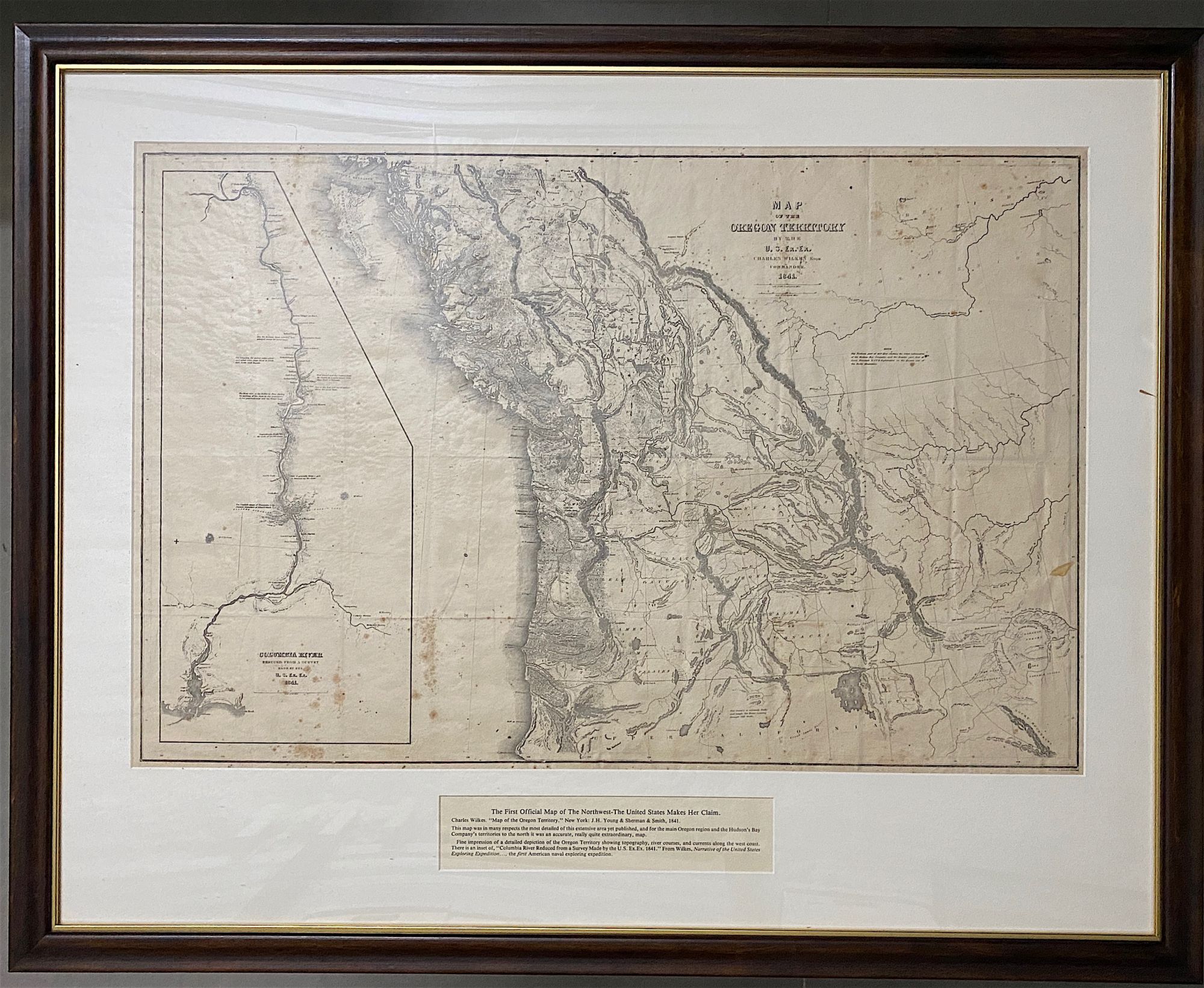
[HUGE MAP OF OREGON 1845]. Map of the Oregon Territory by the U.S. Ex. Ex. Charles Wilkes, Esqr. Commander 1841. [Inset map at left]: Columbia River Reduced from Survey Made by the U.S. Ex. Ex. 1841. [Below neat line at right]: J.H. Young & Sherman & Smith, N.Y.
Philadelphia: 1845 (ca.). Stereotyped map of Oregon, highly detailed, neat line to neat line: 59 x 90 cm. Inset map of Columbia River, neat line to neat line (irregular shape): 54.4 x 24 cm. Scattered foxing and creasing where formerly folded, generally a very good copy. Matted in a handsome maple frame (not examined outside frame). Very good. Item #3444
THE FIRST OFFICIAL MAP OF THE NORTHWEST. It was in many respects the most detailed of this extensive area yet published, and for the main Oregon regions and the Hudson's Bay Company's territories to the north it was an accurate, quite extraordinary map. "The areas now embraced by Oregon, Washington, and Idaho are very well mapped... This map had much influence on the later maps of the area." (Wheat, 457).
A GIGANTIC, EARLY, AND INFLUENTIAL U.S. MAP OF OREGON TERRITORY, stereotyped issue. The map conveys a detailed depiction, showing topography, river courses, and currents along the west coast. The map first appeared as an engraving in Wilkes' six-volume "Narrative of the United States Exploring Expedition," published in Philadelphia in 1845 (for more on the set, see below). Wilkes secured copyright on his "Narrative" of the expedition, and under that privilege published other smaller, cheaper editions. The present map is from one of the editions stereotyped by Fagan ca. 1845 and it is FULL SIZE like the original engraved map. This important map of the Northwest extends from from Cape Mendocino to Dixon's Entrance, and east as far as the Black Hills.
Cohen, Mapping the West, pp. 120-122: “The first official [U.S.] chart of any portion of the West Coast and covers the coast from Cape Mendocino to Queen Charlotte Islands.... The inset of the Columbia River includes geography extending as far as Walla Walla. It is a handsome map printed on imported paper from copperplates purchased in France from the Dépôt de la Marine. The engravers themselves were European craftsmen who not only executed the work, but also trained the American apprentices, including the artist James McNeill Whistler, who served as an engraver on the Coast Survey and learned his craft from those who engraved the Wilkes charts.”
Streeter Sale 3862. Cowan II, p. 683. Hill II, 1866. Howes W414. Wheat, Mapping the Transmississippi West, II, pp. 177-178.
Price: $2,200.00